MnDOT District Boundaries and Contact Information
MnDOT is divided into eight regional district areas. To learn more about your district, visit the official MnDOT website or contact your district office:
Attack Angle
Attack angle (a): The angle between the prevailing transport direction and the alignment of the roadway (Tabler 1994).
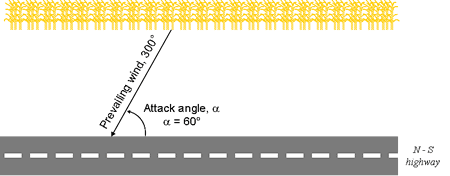
Bottom Gap
Bottom gap: A space between the ground and the bottom edge of a snow fence. The bottom gap reduces deposition of snow in the immediate vicinity of the fence (Tabler 1994).
Fetch
Fetch (F): The length of the area that is a source of blowing snow to a downwind location. The upwind end of the fetch is any boundary across which there is no snow transport, such as forest margins, deep ditches, tree rows and shorelines of unfrozen water bodies (Tabler 1994).

Porosity
Porosity: The fraction of open spaces in the snow fence, where 0 percent is a solid fence and increasing values indicate lower density. This does not include the bottom gap.
Prevailing Transport Direction
Prevailing transport direction: The mean wind direction that corresponds to the direction of greatest snow transport.
Relocation Coefficient
Relocation coefficient: The proportion of winter snowfall water equivalent that is relocated by the wind. It excludes snow retained by vegetation, topographic features and snow that hardens or melts in place (Tabler 1994). For Minnesota, this value ranges from 0.1 to 0.7.
Seasonal Snow Transport
Seasonal snow transport (Qt, ave): The mass of blowing snow that is transported by the wind over the snow accumulation season per unit width across the wind (Tabler 1994).
Setback Distance
Setback distance: The distance between the fence and the road shoulder as measured in the direction of the prevailing transport direction (Tabler 1994). All setbacks for living snow fences are measured perpendicular from the edge of the highway right-of-way line to the nearest row of the snow fence.
Snow Accumulation Season (SAS)
Snow accumulation season (SAS): The season of drift growth, beginning with the first blowing snow event that causes drifts persisting through the winter, and ending when snowdrifts reach their maximum volume (Tabler 1994).
Snowfall Water Equivalent
Snowfall water equivalent: The ratio of liquid precipitation to snowfall. Higher ratios indicate wet snow events (high liquid water content) while lower ratios represent dry snow events (low liquid water content). This varies geographically and throughout the winter season in Minnesota. The November - March statewide average is 0.10 (10 inches of snow is equivalent to 1 inch of water).
Degree vs. Cardinal Direction Table
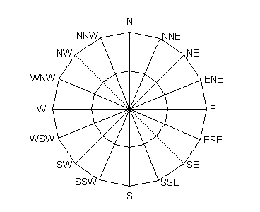
Wind Direction and Degrees
| Cardinal Direction | Degree Direction |
|---|---|
N | 348.75 - 11.25 |
NNE | 11.25 - 33.75 |
NE | 33.75 - 56.25 |
ENE | 56.25 - 78.75 |
E | 78.75 - 101.25 |
ESE | 101.25 - 123.75 |
SE | 123.75 - 146.25 |
SSE | 146.25 - 168.75 |
S | 168.75 - 191.25 |
SSW | 191.25 - 213.75 |
SW | 213.75 - 236.25 |
WSW | 236.25 - 258.75 |
W | 258.75 - 281.25 |
WNW | 281.25 - 303.75 |
NW | 303.75 - 326.25 |
NNW | 326.25 - 348.75 |
Qupot Formula
Qupot = (ui3.8/233847)(f)(86400)(n)
- Qupot is the potential snow transport in kg/m downwind from a fetch of infinite extent with an unlimited snow cover.
- ui is the midpoint of the ith 10-m wind speed class.
- f is the frequency of observations within the ui wind class over a month having n days.
Project Disclaimer
The Minnesota Department of Transportation (MnDOT), in cooperation with the University of Minnesota (UMN) and the Minnesota Department of Natural Resources – State Climatology Office (SCO) provide these data, and the associated maps, tables, and analyses for informational purposes only. As with most government services, these data exist in the public domain, but users are encouraged to pay special attention to the conditions and provisions under which the data were collected, as there were some variations in method of observation. The user assumes the entire risk related to use of this database. Data are provided on an "as is" basis and MnDOT, UMN, and the SCO disclaims any and all warranties, whether express or implied, including (without limitation) any implied warranties of merchantability or fitness for a particular purpose. In no event will MnDOT, UMN, or the SCO be liable to users or to any third party for any direct, indirect, incidental, consequential, special or exemplary damages or lost profit resulting from any use or misuse of this data.
References
Tabler, Ronald D., "Design Guidelines for Control of Blowing and Drifting Snow", SHRP-H-381, Strategic Highway Research Program, National Research Council, Washington, D.C., 1994.